SIGN UP FOR OUR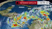
The highest cloud tops, corresponding to the most vigorous convection, are shown in the dark red and pink colors. To be designated a tropical cyclone, deep convection must persist near a closed circulation of low pressure at the surface. Satellite image from the Weather Channel last night.
By Wendy Anders
Costa Rica is taking the brunt of a late-season tropical low-pressure system that forecasters in Central America and the U.S. have their eyes on. Flooding has been reported in several southern Pacific regions of Costa Rica including Golfito and Puerto Jiménez.
Weather in the country’s densely populated San José metropolitan area has gone from hot, dry, and plenty ashy from Turrialba Volcano‘s activity of the past two weeks, to chilly and bone-drenching.
The low-pressure area is likely to develop into a tropical depression or storm in the Caribbean Sea today, reported the Weather Channel last night.
A well-defined low-pressure area was located over the extreme southwestern Caribbean Sea yesterday afternoon by a hurricane hunters reconnaissance flight, said Weather Channel meteorologists. Shower and thunderstorm activity had become more organized as of last night, and environmental conditions appear conducive for potential future development into a tropical depression or a tropical storm.
Due to this potential, the National Hurricane Center (NHC) has designated the area of disturbed weather Invest 90L to identify features they are monitoring.
The area of the Caribbean off the coast of Central America is a typical hotbed for November tropical cyclone activity, said the forecasters.
To be designated a tropical cyclone, deep convection must persist near a closed circulation of low pressure at the surface. Environmental conditions are becoming more favorable for such a development, and the NHC has given Invest 90L a high chance of development into a tropical cyclone within the next two days.
Wind shear – the change in wind speed and/or direction with height that typically rips apart tropical disturbances trying to become depressions – is currently affecting the southwest Caribbean where Invest 90L is located. That wind shear may relax some in the next day or so, however, giving the system an opportunity to develop further.
If a tropical depression does form, it is likely that the system will move slowly and erratically in the southwest Caribbean Sea and eventually move westward into Central America.
Central American countries are being asked to monitor the progress of this system closely, said the Weather Channel.
Given the slow movement, this area of disturbed weather may continue to wring out torrential rain over Central America, even if it never develops. This would raise the risk of flash flooding and possible mudslides, continued the meteorologists.