SIGN UP FOR OUR
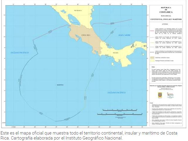
The sentence of the International Court of Justice (ICJ) received earlier this year in favor of Costa Rica, regarding the cases of “Maritime Delimitation Claim in the Caribbean and Pacific Ocean (Costa Rica v. Nicaragua)” and “Terrestrial Frontier in the North Area of Isla Portillos (Costa Rica v. Nicaragua)”, allowed Costa Rica to update the map of the country to include 36, 000 km2 of maritime territory and properly define the maritime frontier between Costa Rica and Nicaragua.
The International Justice Court finally established in February 2, 2018 the maritime boundaries both in the Pacific and Caribbean between both countries and Nicaragua was sentenced to pay $378,890 to Costa Rica for the damages caused in Calero Island also known as Portillos Island or Harbor Head Lagoon.
“The sentence of the ICJ back in February 2 resolved in favor of Costa Rica, legal maters that we had pending with Nicaragua. Currently we have the frontiers in both oceans totally defined with this country, as well as the terrestrial frontier in the north sector of Isla Portillos. This gives security and tranquility to both countries”, commented Manuel Gonzalez, Minister of Foreign Affairs.
After the ruling of the court, the request was made to the National Geographic Institute to work on the new official cartography showing the new limits, this with the purpose of presenting it to the citizens, the public institutions and the police bodies since these last ones are in charge of surveilling the national territory and protecting its sovereignty.
“We hope that in particular for the National Coast Guard Service, the Aerial Surveillance Service and the Frontier Police, this data is of great use for the efficient defense of the Costa Rican territory as well as the proper surveillance and protection of the common heritage of all Costa Ricans”, stated Gustavo Mata, Minister of Security.