SIGN UP FOR OUR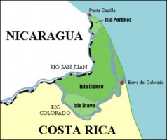
Source: WikiMedia Commons
The Directorate of Intelligence Services (DIS), a shadowy agency in Costa Rica that operates with barely any oversight, may or may not have known that the infamous “Google Maps Invasion” of Isla Calero by a Nicaraguan Army infantry squad since 2008. Such was a recent report filed by journalist Manuel Sancho of online news daily CRHoy.com.
While testifying before the legislative Committee on Public Spending, DIS Operations Director Wilbert Villegas stated that his agency collected intelligence reports about the actions of Nicaraguan civil engineers, topographers, and land surveyors in 2008, two years before the aging and highly controversial former guerrilla fighter Eden Pastora led an infantry squad into Costa Rica, planted the Nicaraguan flag and attempted to set up camp.
Although the main goal of the legislative panel is to reveal the secret budget of the DIS and how it is actually spent, the panel members have not been able to resist questioning the umbrageous agency about what it really does. To this effect, questions about the 2010 invasion of Isla Calero, Costa Rica’s largest island, have been long awaited by former legislator Claudio Monge of the Citizen Action political party (Spanish initials: PAC).
The Use of Google Maps by Invading Forces
Monge suspected that the DIS knew about the intentions of President Daniel Ortega to set up a dredging operation on the San Juan River to correct the flow of the water and reclaim territory he believed to have been lost over the years. This great river is a natural border that has been mutually-agreed by Costa Rica and Nicaragua; however, climate change has resulted in a dry riverbed that has effectively changed existing the cartography that has been de facto until now. It is important to note that Nicaragua does have the right to dredge the San Juan River for the purpose if reclaiming their border; nonetheless, they do not have the right to invade.
According to the recent statements by DIS Ops Director Villegas, alleged incursions by Nicaraguan soldiers and civil engineers into Isla Calero may have taken place as early as 2008. Villegas added that he suspected an imminent invasion and that DIS actually notified former President Oscar Arias about this potential issue, but that nothing was done about it because, according to Director Villegas, it was dismissed as a “sky is falling” – type of situation. The problem with verifying if all this actually took place is that declassifying information created and filed by the DIS is a complex, cloak-and-dagger affair.
The international incident is called the Google Maps Invasion because Mr. Pastora, formerly known as Commander Zero, produced Google Maps printouts to justify the bivouac set up in Costa Rica by the armed Nicaraguan security forces who accompanied him on the dredging operation. When our Ministry of Foreign Affairs complained to Google, the search engine giant revealed that their mapping data on the region was obtained from the United States Department of State. All the same, it was incorrect information that Google quickly amended.