SIGN UP FOR OUR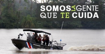
Source: MSP
Earlier this month, the Ministry of Public Security (Spanish initials: MSP) held a special ceremony in Isla Calero that served two purposes: The commemoration of fallen Fuerza Publica officers who died in the line of duty, plus the announcement of a significant donation made by the United States government to augment border security.
Through a security cooperation agreement, the U.S. donated six rigid-hull boats to be used in riverine operations in the Colorado River, which separates Isla Calero from mainland Costa Rica in the province of Limon, close to the pristine Tortuguero National Park. The boats were manufactured by Eduardoño, a renowned Colombian firm that specializes in designing watercraft that can withstand Caribbean and Central American conditions.
Each craft donated by the U.S. is powered by twin 115-horsepower Yamaha engines, and can fit a crew of eight. Each of these small boats have been named after Fuerza Publica officers who made the ultimate sacrifice in service of their country. You can see the tearful ceremony, which was attended by two widows of the fallen officers, in this Facebook video shared by Fuerza Publica.
Isla Calero is the largest island in Costa Rica. Unlike the famous Isla del Coco (Cocos Island), which inspired the late author Michael Crichton to create Isla Nublar of the Jurassic Park fictional universe, Isla Calero is not oceanic; it is actually an insular territory of Costa Rica’s mainland, but it is an island nonetheless. In 2010, Isla Calero made global headlines for being the site of the infamous Google Maps Invasion, which The Costa Rica Star has previously reported on at length:
One of the most bizarre military invasions in modern history was blamed on Google Maps. It was spearheaded by controversial Nicaraguan revolutionary Edén Pastora, who somehow got a job as supervisor of a dredging operation in the San Juan River. The invasion was initially characterized as accidental after Pastora confessed that he was leading a Nicaraguan infantry squad using Google Maps.
It turned out that Google Maps was wrong, and Google promptly acknowledged and corrected its mistake. That invasion prompted an interesting debate among online cartographers who determined that the Nicaraguan army would have been better off using Microsoft’s Bing Maps […]
At the time, President Laura Chinchilla was not amused by the Google Maps invasion, which is one of the many reasons why the border dispute is currently on the docket of the International Court of Justice at The Hague. Over the last few years, Isla Calero has been one of the most delicate sovereign disputes in the region, particularly since the regime of President Daniel Ortega has been less than apologetic for sporadic invasions that followed the one in 2010.
Due to its remote and wild location, the residents of Isla Calero are not only in danger of armed invasions by Nicaraguan soldiers but also from drug traffickers and other unsavory characters who attempt to cross the border by illicit means.